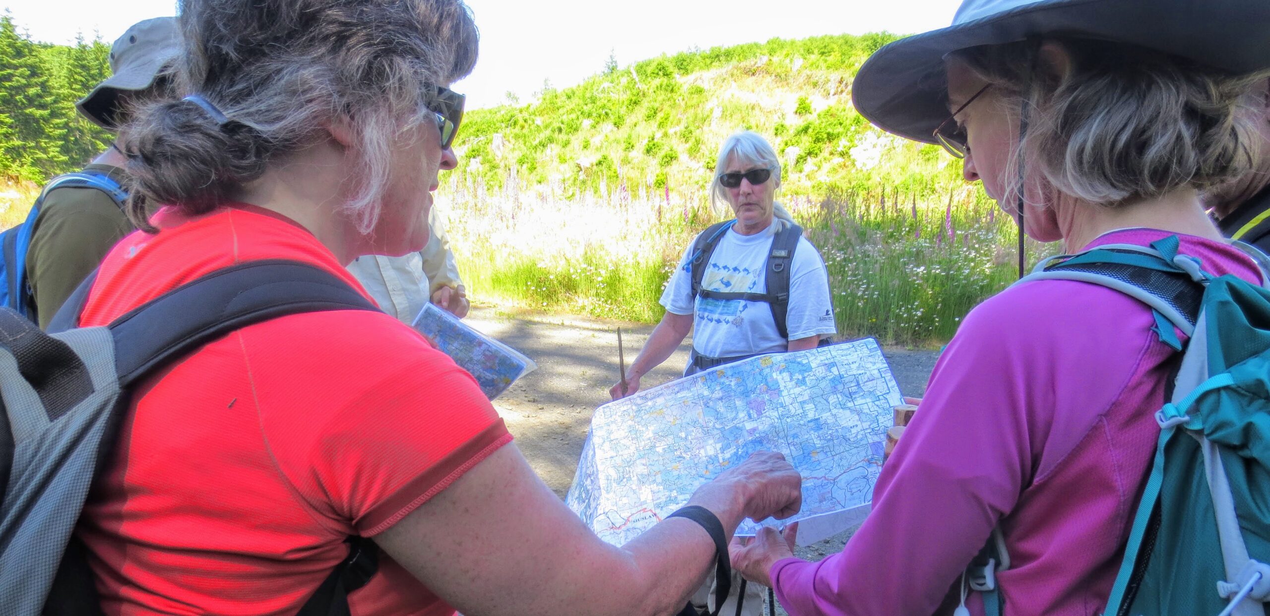
The 60-mile trail can be hiked in sections or done as one 3-to 6-day trip. Cyclists can do it in one or two days.
Shawala Point to Old Peak Road – 9 miles
The Corvallis starting point is Shawala Point Park, at the confluence of the Mary’s and Willamette Rivers. The route is along the Corvallis Philomath bike path into Philomath and proceeds along Applegate Street. At the west end of Philomath the route passes along a fence at the Georgia Pacific Mill near the Highway 20/34 intersection and then along the Highway 34 shoulder to Old Peak Road.
Just beyond the Highway 34 and Old Peak Road intersection is Grange Hall Road, with Marys River Grange Hall just east at 24707 Grange Hall Road. If arrangements are made ahead of time, camping is available at the Grange Hall. A $5 donation is suggested. Contact: Marysrivergrange.org, marysrivergrange@gmail.com, 541-829-2907.
Benton County Fairgrounds Alternative Starting Point to Old Peak Road – 7 miles
An alternative starting point midway between Corvallis and Philomath is the Benton County Fairgrounds on 53rd Street and Reservoir Road. Follow the trail markers south on 53rd Street. It is possible to camp at the Fairgrounds during summer. Contact: www.bentoncountyfair.net, 541-207-8194
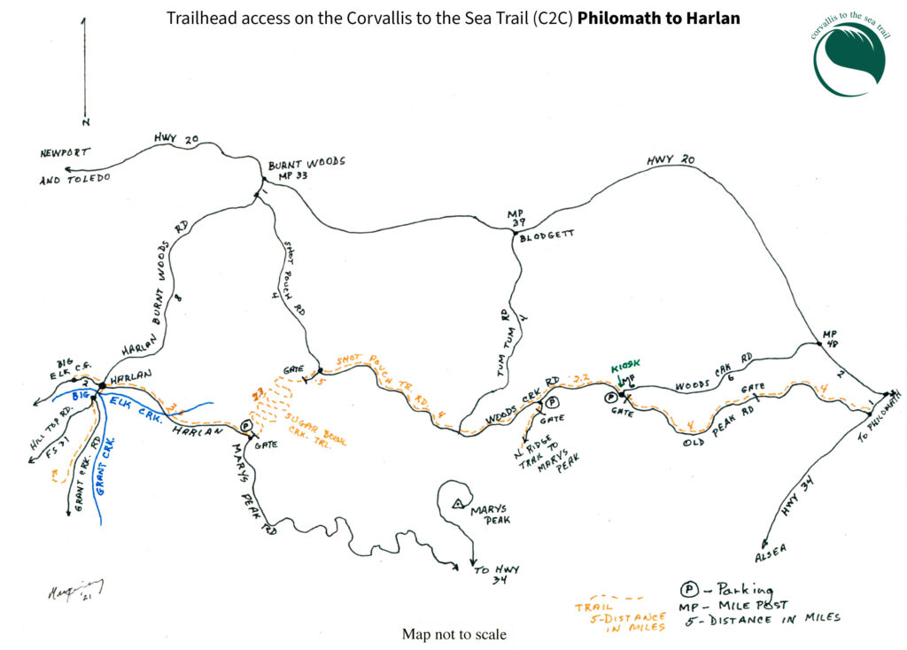
Old Peak Road and Lower North Ridge Trail (LNRT) – 10 miles – elevation gain 1,500 feet
Old Peak Road is a moderate 8-mi. hike on a residential road for 4 mi. and a gated road for 4 mi. Old Peak Road ends at Woods Creek Road at the “upper gate.” The gate is at milepost 6 on Woods Creek Road. The Lower North Ridge Trail begins there. Parking is available at the junction, and there is usually cell phone coverage.
The 2.25-mi. Lower North Ridge Trail is fairly rugged with climbs and descents. LNRT is a popular wildflower hike in the spring with the flora changing each month. The top of the LNRT is the highest point on the C2C Trail at 1,780 ft.
Near the top of LNRT the main North Ridge Trail branches from the C2C and leads to the top of Marys Peak. Camping is allowed on Forest Service land along the C2C Trail beyond the top of LNRT. An accessible creek crosses under the road about 0.5 mi. down from the parking area. Woods Creek road is public, but because the creek is a short distance onto private land, camping near the creek is not possible.
Woods Creek Road, Shot Pouch Trail Road, Shot Pouch Road and Sugar Bowl Creek – 7 miles
This hike combines open road, gated road, and trail with a moderate drop of 1,400 feet in altitude. In Benton County what is called Woods Creek Road changes to Shot Pouch Trail Road in Lincoln County. The trail passes through actively logged lands. Where trees were logged twenty years ago views are now obscured by new growth. Where land has been recently logged new vistas of the Coast Range have opened.
At milepost 4 on Shot Pouch Trail Road the C2C trail turns uphill onto Shot Pouch Road. At the top of Shot Pouch Road there are four roads called “The 4-Way.” There are pullouts that can be used for parking, the best is in the SW quadrant. Do not block the gate or impinge on the logging roads. C2C is marked, going slightly downhill to the west. Walk around the gate and continue on the road for a little over 1 mi. At that point the C2C Sugar Bowl Creek Trail turns down to the left. The 1 mi. long middle section here is the only Forest Service land between Woods Creek Rd and Big Elk Campground. Beyond the Forest Service land the trail continues on a private gravel road for 1.3 mi. to a gate at the Harlan Road.
Harlan Road and Big Elk Campground – 5 miles
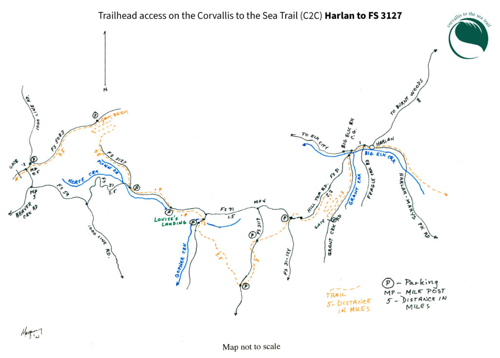
The gravel Harlan Road passes through the Big Elk River valley with homes and farms and moderate traffic. After passing through the junction at Harlan the route continues a mile to Grant Creek Road. At this junction the trail splits, the route to Big Elk Campground goes straight for another 0.5 mi., the route on to the coast turns left onto Grant Creek Road. At Big Elk Campground a campsite with a picnic table, water spigot, and fire pit is available just for hikers and bicyclists. There is a creek for wading, water from a well, an outhouse, and firewood can be purchased. There is a fee of $5 per hiker or biker per night. Motor vehicle campsites are available to hikers if they are not in use. If everything is full, try to share the C2C Trail campsite or ask about an overflow area for hikers.
After Camping at Big Elk – 2 miles to Grant Creek Trail
Walk back 0.5 mile to the junction with Grant Creek Road. Turn right onto Grant Creek Road.
Shortly after the bridge the C2C Trail continues to the left on the lower road, while FS Road 31 goes up the hill to the right. Continue on Grant Creek Road for 1.25 mi. There is a small pullout on the right where Grant Creek Trail goes up to the right along a small creek. The cattle guard and gate on the road are just beyond the trailhead.
Grant Creek, Hogback, Branch Creek and Bull Run Trails – 4 miles
These are beautiful recently built trails on moderately difficult, uphill uneven terrain for 4 mi.
The Grant Creek trail ascends and crosses a small stream and then climbs steadily for 0.7 mi. The trail crosses FS 31 to the Hogback section. After 0.5 mile on the Hogback the trail re-crosses FS 31 to Branch Creek (FS 31-124).Occasionally campers are parked there, as there is plenty of parking. An overgrown old road leads down to Branch Creek(s), several of which run all year. There is no water for the next 7 mi.
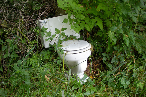
After crossing FS31, the 1.5 mi. Branch Creek trail section immediately heads up the hill to the right. At the top of the trail is the “Toilet Bowl Landing,” named for the remains of a porcelain toilet bowl and tank found there. The Toilet Bowl Landing is a beautiful place for a rest and there is usually cell phone coverage there.
Continue up the trail to meet the FS 3119 Road (Bull Run Road) where the C2C goes left up Bull Run Road for about 150 yards. Lower Bull Run Trail takes off to the right. It crosses FS3119 and becomes Upper Bull Run Trail. The C2C trail reaches its second highest point, 1,740 feet, near the top of Upper Bull Run. It then descends and crosses the road. Upper Bull Run leads right onto Gopher Ridge Road.
Gopher Ridge Road and Gopher Creek Trail – 4 miles
Gopher Ridge Road is a beautiful decommissioned forest service road. There is a gentle descent of 640 feet.
At the bottom the C2C follows FS 3125 (Gopher Creek road) to the right for 0.2 mi., crosses Gopher Creek and turns left onto Gopher Creek Trail*. The trail crosses a small tributary and goes uphill for 1 mi. to a short spur road, FS31-123, with a grassy landing at the bottom and a pullout at the top on FS 31.
* Gopher Creek Trail is closed to all users from Nov 1 to Feb 28 to protect sensitive habitat. Hikers who need to by-pass this section during the seasonal closure can continue up FS Road 3125 to FS Road 31 (Hilltop Road) and go west on FS Road 31 to once again hit the regular trail route (about a 2 mile detour around the 1-mile closure).
Palmer Mountain Trail and FS Road 5083– 9 miles
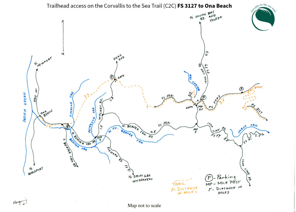
From the FS 31-123 pullout the trail goes west for 0.9 of a mile on paved FS 31 to FS-3127. FS 3127 is a beautiful decommissioned forest service road that climbs about 600 feet to Errol Ridge. Hikers often rest at the “rock fall,” but it can be dangerous due to the potential of rock falling.
After 2.1 mi. the road ends and the trail passes onto beautiful 2.3 mi. Palmer Mountain Trail, with one creek crossing, and up past Palmer Mountain on an old road trace. Near the top of the trail there is a last view of Marys Peak before the trail turns west. A few hundred yards beyond that, hikers get the first glimpse of Yaquina Bay. After climbing around a berm, the trail is on decommissioned FS Road 5083 for 3.6 mi., with a gentle descent. FS 5083 briefly enters FS Road 59 (1000 Line Road).
FS Road 5081 to Peterson Creek Trail and Hitselberger Road – 7 miles
The trail follows FS Road 59 for almost 0.25 mi. before turning right onto gated FS 5081. At 0.4 mile in on FS 5081 there is a 0.3 mi. side trail down to a creek.
FS 5081 is a moderate hike on 5 mi. of gated and decommissioned Forest Service road and leads to the pretty 0.5 mi. Peterson Creek trail section, the western-most part of the trail on Forest Service lands. At the end of the Peterson Creek trail the route enters private timberlands of the Hitselberger Ranch. In all, this entire section is a gradual descent with a few ascents from 1,000 feet until it drops down steeply to Peterson Creek – then a 0.5 – mi. climb 300 feet up at the end of the Hitselberger road. At that point the trail goes left onto Lincoln County’s Wolkau Road.
Wolkau Road, Hitselberger Trail, Hancock Road and North Beaver Creek Road – 5 miles
Follow Wolkau Road downhill for a short way until reaching the C2C sign on the right, exit the road, and follow the trail through the Hitselberger property. The trail heads down a small service road and crosses Bowers Creek on a small foot bridge and heads right onto a rustic dirt road sometimes used by cattle. After about a quarter mile the trail turns left and climbs steadily for 0.75 mi. with an elevation gain of 400 feet. The trail wanders through a forested hillside on an old roadbed before leaving Hitselberger land and entering those of Hancock Forest Management.
A combination of old road and new trail leads to a main logging road which parallels Simpson Creek for almost 1 ½ miles downhill to the Weyerhaeuser gate at North Beaver Creek Road. The route then uses paved North Beaver Creek Road for about 1.9 miles to Ona Beach, passing two Beaver Creek Natural Area sites along the way. Hikers carefully cross Highway 101 to Ona Beach to complete the hike.
